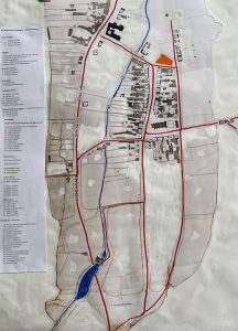
This survey came to light as a result of a study by Joyce Evans in her history studies at Durham University. ‘Survey of Boroughbridge 1611’ was discovered at Nottingham University. The handwritten document in 17th Century English, which is quite difficult to read, has been transcribed for us by Joyce. Some of the street and place names are familiar to us today, Fishergate, Market Place, (Little) Roecliffe Lane and some are not, Walkergate, Micklegate, Briggate. It also lists all the male residents that were entitled to vote, their names and street names. The plan is to build on this information, try and create a map of the town at the time and find out more information about the residents and places.
Progress Status 29.10.24
Information established so far.
Background Information
This was the 8th year into the English reign of James I following the death of Queen Elizabeth I in 1603. It was of course a time of great intellectual achievement, the time of William Shakespeare, Ben Jonson, Christopher Marlow, the King James Bible and other literary greats.
It was a time of religious turmoil just 6 years after the Gunpowder Plot to blow up King and Parliament, but aside from religious issues, James believed that he was King by divine right, aspiring to rule as absolute monarch, but he had to contend with the checks and constraints of Parliament through which he could raise finance.
James was a profligate King who spent lavishly on his life style, particularly on court favourites, but with poor grasp of the serious economic problems he was confronted with. He needed Parliament to raise funds but lost patience with demands and issues the MPs raised Hence Parliament was dismissed without agreement being reached. He was in continual conflict with Parliament.
James’s eldest son and heir was Prince Henry aged 17 at the time of the Survey, and it appears that he had been bequeathed entitlement to the income from property in Boroughbridge. Sadly he died a year later in 1612, his brother Charles becoming heir to the throne. So this was the wider background in the year before Prince Henry died.
Survey
- The survey confirms that Boroughbridge (and Aldborough) were still part of the Honour of Knaresborough in 1611. It would presumably so remain until the Civil War of the 1640s when the Knaresborough castle administration was effectively destroyed.
2, The present Boroughbridge High Street was called Mickelgate and the residents on the western side, starting at the (current) Black Bull end were:-
William Aldborough (now Black Bull)
Christopher Mautus
Richard Catton
William Rawlingson
William Fitler
Robert Stobbard
Thomas Smithson
Richard Rawlingson
William Moare
St Robert of Knaresborough
St Robert of Knaresborough
William Pulleyn
Heirs of Thomas Wilson
Christopher Smithson
On the Eastern side, starting from the north (now Hall Square end) the residents were:-
James Lawre/Lowe and Henry Bentley
Thomas Smithson (2 burgages)
William Bentley (2 burgages)
Richard Knaggs
Robert Smith
Robert Flint
(Heirs of) John Russel
Robert Stobbard
Anthony Clark
William Gilbertson
- The street from the Ure bridge to the current Crown was called Briggate, there was no mention of Horsefair, which I suspect became the name of the street following the grant of fairs by Charles II in 1670, which of course included the Barnaby Fair for the trading of horses.
The residents on the western side starting at the bridge, now the Three Horse Shoes were;-
Christopher Mautus (now Three Horse Shoes)
Heirs of Sir Richard Mauleverer
Thomas Mauleverer
Heirs of Ralph Mautus and Thomas Smithson
Lands of Richard Hutton called Smithy Garth
Waste held by CharlesTanckard
Heirs and Assigns of Robert Brown
Lands of Thomas Tanckard called Guest Close
Lane leading to Roecliffe – currently Roecliffe Lane
Boroughbridge Common
- As part of the passage dealing with what used to be the Great North Road, it is recorded in this survey that the turn off going north at the present recreation field was called Back Lane. In 1611 it appears that Back Lane originally started at the old Great North Road, proceeded north down what is now Church Lane and finished up at the bottom of the present Back Lane just off Hall Square.
5. Fishergate existed as now, but there was also a street called Fishergate Close. The bridge over the Tutt was called the Tutlad bridge.
- The bridge over the Tutt in St Helena was named the Jugan Jergan bridge. There is however no mention of a street named St Helena, the street name at the time was possibly Little Rocliffe. This requires more research to confirm, but the name St Helena was probably thus named after the incarceration of Napoleon Bonapart in 1815.
- Recent interpretation of the document has indicated that Walkergate was probably on or near the present New Row. There is evidence of very old buildings at the back of the present east side of New Row.
Thomas Smithson, Thomas Tanckred had properties there.
8.. Only two bridges over the Tutt are recorded not three as there are now, prompting the question – which bridge is missing in the survey? This has been a puzzle and has given rise to much thought and speculation. The most likely explanation is that at that time the Great North Road crossed the River Tut by a ford, and that the current bridge was built later than the date of the survey. In 1611 it is unlikely that the horse traffic on the Great North Road would have been very heavy compared with later years with the advent of the Mail Coach business and the Turnpike roads. It is well known that at that time the roads generally in the country were in a very poor state. Blind Jack of Knaresborough vouched for that in his travels to and from London in the early 18th century.
The Little Mills recorded in the survey were probably accessed by land. There was a lane from the present New Row (then Walkergate) down to the River Tut and on to the Little Mills. It ran between the old Primrose Cottage and the current Eastgate housing estate, turning left at the Tut and on upstream to the Little Mills. They could of course also have been accessed from the Great North Road.
- A passage in Records of a Yorkshire Manor p186 referring to times from 1655 onwards reads as follows:-
“Formerly Fishergate Street ran from the Market Place to Fishergate Nab on the Ure, and there were six old burgage tenements abutting on it, besides some fishermen’s cottages on the Tutt Beck. These have all been absorbed in Boroughbridge Hall and grounds”
- From the 1611 survey document, it has not yet been worked out which was the present Fishergate and which was the street running down to Fishertgate Nab
- There is no mention of the Church but the Toll Booth is recorded, mentioning that “His Highnes’s courts for the Manor of Aldborough and Boroughbridge are held” Also that “the rooms underneath are let by the bailiff of the Liberty of Aldborough to contain poor people”
Download map here: